Freshwater Wetland Loss in the Houston Metropolitan Area: A Quantitative Estimate of the Loss between 1992 and 2010 (2012)
 Download Full Report Download Factsheet
Excerpt: Report Summary
Since 1992, the Greater Houston Metropolitan Area has lost at least 5.5 percent of its natural freshwater wetlands. Although a 5 percent loss in 20 years is unsustainable by any accounting, some areas experienced loss at rates that are catastrophic. For example, Harris County lost almost 30 percent of its freshwater wetlands, including most prominently the iconic prairie pothole-pimple mound complexes.
The eight-county Houston area is one of the fastest growing in the country. Metropolitan growth means development, which means the loss of wetlands. When wetlands are lost, with them go important ecological services for both nature and people.
Until now we have not had a clear picture of just how many acres of wetlands we might be losing. We report here our attempt to quantify freshwater, non-tidal wetland loss from 1992 to 2010 in the greater Houston region.
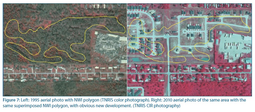
We developed a simple method for quickly estimating natural fresh-water wetland loss. The method, a conservative approach that provides a minimal loss estimate that policy makers can rely on, compares National Wetland Inventory (NWI) maps developed in 1992–93 to more recent digital aerial photography.
The study found that most of the losses occurred in rapidly growing Harris, Montgomery, Brazoria, and Fort Bend Counties. The greatest loss occurred in Harris County: 15,855 acres (29 percent) from 1992 to 2010. This acreage loss is more than double that of the other seven counties combined. Losses in other rapidly growing counties, however, are on a track to equal that of Harris County.
Overall, the study reveals that development is seriously affecting the freshwater wetland resources in the Greater Houston Metro Area. These freshwater wetlands are the headwaters for virtually all of the water bodies feeding into Galveston Bay. Continued loss at the rates documented here will very likely have grave implications for the long-term health of the Galveston Bay System because it is losing the principal means of cleaning the polluted runoff that enters the bay.
