Galveston Bay Wetland Mitigation Assessment and Local Government Capacity Building (2014)
This project was led by Lisa Gonzalez, Vice President of HARC, and John Jacob, TCWP. The project team partnered with the Texas General Land Office to examine the long-term status of wetland permit and mitigation activities in the Lower Galveston Bay watershed. The original report was released in August 2014, with TCWP revisions to the original report for minor adjustments to numbers and formatting released in August 2015.
Download Full Report
Download Fact Sheet
View The Houston-Galveston Regional Wetland Impact Screening Tool, regional decision support tool that can provide information to local governments and citizens, allowing them to access information describing potential development impacts to wetlands, floodplains and water quality
Excerpt: Report Summary
The fill or destruction of “jurisdictional” wetlands (i.e., wetlands that are regulated) requires a permit from the US Army Corps of Engineers (USACE), and in many cases the destruction of those wetlands must be offset through a process known as mitigation. Compensatory wetland mitigation requires the replacement of lost wetland values and functions, often through the construction of replacement wetlands, and sometimes through the preservation, enhancement, and restoration of existing wetlands. The USACE permit documents the requirements the permittee must complete to offset the wetland destruction that is a result of their authorized activities.
Wetlands are being lost at an increasing rate in the greater Houston region. In the regional epicenter, Harris County has lost over 30% of the freshwater marshes and swamps that existed in 1992, primarily to development. Loss in some of the surrounding counties is beginning to approach these numbers (Jacob et al 2014; Lester and Gonzalez 2011).
“No Net Loss” is the official policy of the wetland mitigation program administered under Section 404 of the Clean Water Act. The objective of the federal No Net Loss policy is to ensure that wetland area and wetland functions impacted or lost through development are replaced by the creation or restoration of similar wetland habitats and functionality, such that water quality in downstream waters is not degraded. However, without examining the long-term status of permitting, permit compliance, and compensatory mitigation, there is no way of knowing whether the No Net Loss policy is effective, and therefore whether changes in policy implementation might be in order.
Wetland habitats lying outside of the 100-year floodplain are largely unprotected by the federal regulatory system as it is currently implemented in the study area. The term “no net loss” should therefore be clarified to mean “no net loss of jurisdictional wetlands”.
Two primary objectives were proposed as a part of this project:
- Evaluate the completeness of records documenting the USACE wetland mitigation program in the 8-county region surrounding Houston, Texas between 1990 and 2012. Certain wetlands are regulated by the USACE because wetlands play a critical role in maintaining the aquatic integrity of our nation’s waters.
- Develop a regional decision support tool that can provide information to local governments and citizens, allowing them to access information describing potential development impacts to wetlands, floodplains and water quality.
Permit Summary: 1990 -2012
HARC and TCWP acquired 404 wetland permit information for 7,052 permit records from the USACE Galveston District Office for the period 1990 to 2012 in eight counties of the Houston-Galveston Region: Brazoria, Chambers, Fort Bend, Galveston, Harris, Liberty, Montgomery, and Waller. Of the 7,052 permits, 80% were issued in three counties: Harris (2,512 permits or 36%), Galveston (1,853 permits or 26%), and Brazoria (1,247 permits or 18%). We also determined that during this time period 6,262 (89%) wetland permits issued in the 8-county study area were located within the 100-year floodplain, meaning that wetland impacts outside of the floodplain are accounted for in only 11% of permits. Little information describing acreage of wetland impacts and compensatory mitigation was available in the database of 7,052 permit records, there for a more detailed analysis of permit records was required.
Objective 1-The Mitigation Record
HARC and TCWP examined in detail a random sample of 95 permit records, plus an additional 28 semi- randomly-sampled permit records, obtained from the USACE Galveston District Office, for a total of 123 records out of the total database of 7,052 permit records, for a sampling rate of just under 2%. The analysis was strictly an assessment of the mitigation documentation. There was no ground-truthing to verify mitigation, and no on-site assessment of the adequacy of the mitigation in terms vegetation establishment, for example. TCWP examined aerial photography where possible.
The ultimate measure of success in terms of the no-net-loss program is the equivalence of functions and values mitigated to those of the impacts. Theoretically a 1:1 ratio would suffice, but given the uncertainty of success associated with created wetlands, a significantly higher ratio is usually required. In other words, compensatory mitigation wetland acres should be substantially greater than impact acres.
This study looks at data in terms of a permit’s full compliance (avoidance, minimization, and compensatory mitigation). Assessment of all permits, not just those requiring compensatory, was completed for the full sample of 123 permits. However, after reviewing all 123 permits, it was found that 13 permits (11%) were issued where subsequent activity never occurred in jurisdictional waters of the US. These permits were filtered out of the analysis to achieve a sample of 110 permits where impacts actually occurred in jurisdictional waters.
For 110 permits, 54% (59/110) were compliant in terms of full mitigation (avoidance, minimization, and compensatory mitigation) (see Figure 11). For the 51 non-compliant permits, 13 were non-compliant due to an issue with avoidance or minimization, and 38 were non-compliant due to an issue with compensatory mitigation. Sixty-two of 110 permits where work occurred in jurisdictional waters (56%) required compensatory mitigation. This means that 61% of all permits that required compensatory mitigation from the 110 sample of permits were non-compliant with compensatory mitigation requirements.
The sample of 110 permits where work occurred in jurisdictional waters accounted for 358.90 acres of wetland impacts, with mitigation requirements of 1,247.24 acres of wetland mitigation and purchase of 58.81 mitigation bank (MB) credits. The 48 permits from the 110 sample which did not require compensatory mitigation only accounted for 2.77 acres of wetland impacts and no required wetland mitigation. Of the mitigation requirement for the 62 permits where compensatory mitigation was required, only 186.19 acres and 50.31 credits of mitigation were documented as completed in the administrative record. This means only 15% of required mitigation acreage and 86% of required mitigation bank credit purchases were documented in the administrative records for permits in the 62 permit sample where compensatory mitigation was required. (see Table 3).
In summary, of the 62 permits which required compensatory mitigation, 1,247.24 acres of wetland mitigation and 58.81 credits were required for 356.12 acres of wetland impacts, a 3.67 to 1 required combined wetland acre and credit to wetland impact ratio. Only 186.19 acres and 50.31 credits of mitigation were documented as complete or likely complete in the permits’ administrative records. Given that these 62 permits resulted in a total of 356.12 acres of wetland impacts, the documented combined wetland acre and credit to wetland impact ratio was only 1 to 0.66 (see Table 4).
The record for mitigation for permits solely utilizing mitigation banks for compensatory mitigation requirements was significantly better. For these 10 permits, 47.629 mitigation credits were required to be purchased to compensate for impacts to 33.03 acres of wetland. Documentation for purchase of mitigation credits existed in the administrative record for 39.126 credits (82% of the requirement). The ratio of wetland impacts to documented credit purchase was 1 to 1.2 (see Table 6).
If the random sample of full-permit records was an accurate snapshot of permitting activities in the region, these numbers suggest that the Houston-Galveston Region may not be achieving No Net Loss of critical wetland functions and values. The continued degradation of the region’s water bodies as evidenced by 303(d) listed impairments is consistent with these numbers, and does not bode well for the future integrity of these water bodies.
There was no evidence of unprofessional or inexpert conduct on the part of the USACE and its staff who are committed professionals. In fact, this study revealed that the USACE exceeded their own targets for internal audits of the permit records.
An assessment of mitigation banks (MBs) and In Lieu Fee programs (ILFs) in the region was also conducted. HARC collected publicly available mitigation bank ledger details from the USACE Regulatory In lieu fee and Bank Information Tracking System (RIBITS). Comparisons between the RIBITS ledger data and the ledgers received directly from the mitigation banks showed that the majority of the RIBITS records that were compared were correct. However, we found only 3 permits where the permitted impacts to wetlands were within the same HUC 8 watershed as the mitigation bank in which credits were purchased. If mitigation bank and in-lieu fee mitigation increases, then more wetlands and the ecosystem services that they provide will likely be lost from their original watersheds and mitigated in different watersheds.
Based on evidence found in reviewed permit administrative records, this study revealed that current compensatory mitigation practices may not be effective at maintaining the aquatic integrity of regional waterways. Importantly, most of the wetland loss we are witnessing now does not even require a permit, much less mitigation, because the federal permitting process considers that the vast majority of freshwater wetlands in this region are not in any way connected to the bayous and creeks that drain this region.
Objective 2 – The Houston-Galveston Regional Wetland Impact Screening Tool
Because so few wetland permits account for impacts outside of the 100-year floodplain, local development decisions in the Houston-Galveston region are often made independent of the federal wetland permitting process. Many local governments in the region are concerned about water quality and flood issues and often local permitting processes account for on-site sewage facilities (septic systems) and development in the floodplain. However, there appears to often be a disconnect between the issues of water quality and flooding and the role that wetlands play in providing these important ecosystem services. Therefore, the second objective of the project seeks to build capacity of local governments and citizens in the Houston-Galveston region so that they might participate more directly in the protection of the remaining wetlands in the Lower Galveston Bay watershed through impact avoidance.
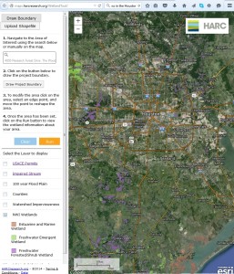
HARC designed a regional decision support tool known as the Houston-Galveston “Wetland Impact Screening Tool” to facilitate watershed-based decision making. The target audience is citizens and local government decision makers involved in making local permitting decisions for new development in the region. The mapping application can be accessed at http://maps.harcresearch.org/WetlandTool/.
Potential development project sites in the Houston-Galveston region can be 1) searched by address, 2) drawn in using a computer mouse, or 3) uploaded as a shape file. The tool also calculates acreage of wetlands impacted, location per the 100-year floodplain, associated 303(d) impaired streams, and mitigation bank service areas that overlap with the project. The tool also provides the percent impervious surface coverage within the watershed and notifies the user of potential impacts on surface water quality.